Final Day on the Rota Vicentina : Vila Nova de Milfontes to Sao Torpes
Final day on the Rota Vicentina
Porto Covo and Sao Torpes Portugal
Today’s stage on the Rota Vicentina was listed as hard in the guidebook, and after overhearing several southbound hikers at the end of their first day on the trail last night, we feared it would live up to its reputation. The distance from Vila Nova de Milfontes to Porto Covo is approximately 20 km. If we could cover it before noon, this would give us the chance to trek the additional 10 km to Sao Torpes, and the end of the Fisherman’s Trail. While we did not expect any technical difficulties on the trail, we nonetheless figured that 4-6 hours of walking up and down dunes, along soft beaches and in deep sand would be tiring.
We were awake early, ready to set out shortly afterward. A quick Google search revealed that most of the cafes in Vila Nova de Milfontes were either closed today or not open for several hours. Admittedly, there was one bar claiming to be open at 7 AM, but neither of us was up to walking across town to see if this was actually the case. As such, we once again made coffee in our room and headed out without breakfast … hoping that the trail would provide.
Locking our door and depositing our room key, we began the day’s hike by navigating the streets of Milfontes, and meeting several stray cats along the way. Beyond the town, the first 3 or 4 kilometres were easy walking as we followed a hard-packed dirt track around open fields. In short order,r we arrived at Ponta das Barcas, a tiny harbour filled with fishing boats that had been hauled out of the water. Here we found an open bar and gratefully enjoyed a morning café com leite and croissants.
Fisherman’s Trail Coastline and Birds
Energized from breakfast, we returned to the Fisherman’s Trail and picked up a narrow sandy track that took us back out to the coast. Here, along the Atlantic shoreline, amid a gorgeous sunny morning, we located the wooden posts with their familiar green and blue trail blazes that would lead us steadily northward. From Praia Barcas onward we walked through what the guidebook terms 'the largest area of lithified dunes' in Portugal, which is host to a huge variety of rare botanical species. While fascinating, it also meant that much of this section of the Rota Vicentina was deep sand that was regularly churned by hundreds of feet passing through, which made for tough hiking.
Moving along the spectacular Alentejo coastline, we navigated cliffs, periodic coves, and beaches. The scenery was stunning and the trail often wove very close to the rocky edge, which provided us views under the eroded coastline. Amid these overhangs, we were able to see interesting caves and catch sight of several species of birds including Jackdaws, Rock Pigeons, and House Martins who were zooming in and out.
Having set out early in the day we had the trail to ourselves for the first few hours. This allowed us to spot several of the region’s elusive rabbits, with their white tails. We also spent some time observing the large stork nests just off the coast. Beyond the birds, rabbits, and lizards our only companions were a number of intrepid Portuguese fishermen who dotted the ocean’s edge, standing precariously on the jagged rocks below as waves crashed amid them.
Praia do Malhao and Praia do Queimado
The trail continued northward, tracing the coast as we passed both Praia do Malhao and Praia do Queimado. Throughout this section, the greatest challenges were that there was little shade amid the morning heat and the fact that a number of local trails confusingly intersected with the Rota Vicentina. With that said, the trail continued to be well-marked and our course was easy to follow.
Beyond a stretch of vast sand dunes, we reached a length of wooden boardwalks and observation decks which stuck out from the shoreline and provided panoramic views of the sandy coastline. Here camper vans were set up for the day or season in the parking lot, and young families played on the beaches. As we took our first break for the day we began to see the first southbound hikers, who were in the midst of their first section of the Fisherman’s Trail from Porto Covo to Vila Nova de Milfontes.
.JPG) |
| White Stork nests near Vila Nova de Milfontes, Portugal |
Venturing on, we were fascinated by the marvellous wildflowers which were growing in the shelter of the sand dunes. Indeed, over the past couple of weeks, we have been constantly amazed by the biodiversity and plant life that we have found along this rugged coastline. This is especially amazing given the weather conditions and temperature extremes that life must contend with to not only survive but also thrive here. This region experiences blazing heat and droughts in the summer, sandy soil conditions, strong winds, and salty ocean spray. Despite all of these pressures, over the last couple of days, we have seen stands of conifers, puddles of rosemary, and huge dunes covered in succulents – each of which serves as testimony to the tenacity of nature to thrive in an environment that daily makes us wilt and struggle.
Our path eventually left the beach and cut inland, separating us from the roar of the ocean and the cooling breeze. Weaving through a stand of sparse trees we met the bulk of today’s southbound crowd of hikers. From 11 AM until noon we would both pass and be passed by more than 140 hikers on their way to Milfontes. Amid this crowd of adventurers, the trail turned back towards the Atlantic, bringing us to Praia do Queimado, whereupon the coast took on a different feel as the sand and hoodoo-like cliffs took on a very strongly yellow colour.
Forte de Nossa Senhora da Queimada
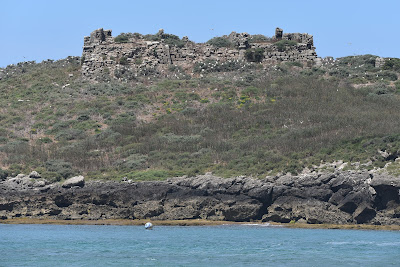
Soon we reached a fort overlooking a small rocky island, which itself had the ruins of another citadel on it. We discovered upon our arrival that the fortification on the mainland was a historical site by the name of Forte de Nossa Senhora da Queimada. Unfortunately, it closed at noon, and as we had arrived only 5 minutes before this time, we were turned away by the staff. This fortress, also known as Forte do Pessegueiro, was designed in 1588 to protect a local port from piracy. This citadel would be constructed on and off for over a century, and its design was later changed in the late 17th century as it was deemed essential for coastal defence amid Portuguese independence. By 1957 it was declassified as a military outpost and named a Public Interest Monument. Since then it has had sections renovated and repaired, and it is now open to the public.
Beyond the entrance of the fortification, we were grateful to discover A llha, a quaint restaurant and bar. With Porto Covo only a short distance away, and ready for a break, we sat on the shaded patio and enjoyed a café com leite, large slices of almond cake, and a glass of iced tea. Sitting there, we were soon joined by a large number of southbound hikers. Many of those who came in wore day packs, had started late, and were drinking rounds of beer to celebrate the beginning of their trek, proclaiming that it was “only a little 16-kilometre walk on a beach” from this point onward. Their enthusiasm at the outset of their hike on the Rota Vicentina was re-energizing to be near. However, while 16-25 km per day is par for the course on most trails, describing almost any section of the Fisherman’s Trail as “only…a walk on a beach” does little to acknowledge the realities of trekking through churned-up sand on an exposed coastline.
Not for the first time, I wondered whether we too had underestimated the physical demands of the Rota Vicentina before setting out? Paying our bill and heading back out onto the trail, part of me was envious that for almost everyone we met today, their adventure was just beginning as we neared the conclusion of our time in southern Portugal.
Ilha do Pressegueiro
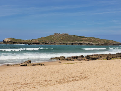
Leaving the bar, the trail led back to the waterline and the beach. From there we could distinguish the nearby red roofs of Porto Covo and see down the coastline to Sao Torpes. Seeing our destination on the horizon, my excitement to complete the trail was replaced with a reluctance to finish our journey.
Nearby, just off the coast was a small island whose grassy slopes were covered in Little Egret and gull nests.
Nearby, just off the coast was a small island whose grassy slopes were covered in Little Egret and gull nests.
This small piece of land, named Ilha do Pessegueiro, has been occupied since the 3rd century BC, first by the Carthaginians and then by the Romans, following the Second Punic War and the invasion of the Iberian Peninsula. Apparently, there are still remains of a Roman port and wall that can be seen. The ruins, which are presently observable, are the remains of a 16th-century Portuguese outpost by the name of Forte de Santo Alberto do Pessegueiro, which along with the Forte de Nossa Senhora da Queimada were intended to prevent piracy along the coast. Presently, it seems to be host to a huge number of families of birds.
Porto Covo Portugal
Crossing the beach, the Rota Vicentina again climbed up onto a stretch of dunes before leading us down into a tiny cove. Leaving the sandy terrain behind, we followed a small road down into the fishing harbour at the edge of town - which was the easiest walking we had done today. On the outskirts of Porto Covo the trail crossed a small sandy beach and a trickle of a riverway. There, dozens of species of birds were chirping, bathing and flitting around. After so many days in the rising temperatures of southern Portugal, we could appreciate their joy amid the shaded waterway.
.JPG) |
| European Goldfinches taking a bath in the stream |
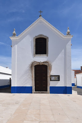
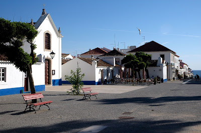
Leaving the bathing birds, we climbed into Porto Covo along a short but steep cobblestone roadway. Having ascended, we were greeted with the sight of an old-style red telephone booth that had been tastefully transformed into a small community library. Then, only a couple of blocks later, we spotted the first yellow arrow and shell marker for the Camino Portuguese that we had not seen since leaving Faro. Wandering the city streets to the centre of town, we wove past rows of buildings that had been whitewashed in the usual fashion, and trimmed with vibrant blues, yellows, and reds. Beyond its traditional look, however, Porto Covo is very clearly a seaside tourist town and vacation spot. Signs for vacation rentals, bars with English menus, tourist knickknacks in the shops, and higher costs are testament to this fact.
Despite being surrounded by throngs of people who “just needed to get some shopping done” the center square of Porto Covo was welcoming and beautiful. Walking along a cobblestone street we soon found ourselves on a road lined with a wonderful market, gorgeous bakeries, and cozy restaurants – each with welcoming patio seating. Here we enjoyed a cold pasta salad and ice teas before walking out to the Miradouro de Porto Covo, a scenic park that overlooks the area’s dramatic coastal cliffs and local beaches.
Wandering back into town, we eventually found our accommodations for the night, which was a confusing process as the entire street was filled with room rental signs all with very similar names. Regardless, we soon got checked in and took cooling showers before going back out again. Neither our hiking for the day nor the Rota Vicentina was done yet.
While there is little denying that Porto Covo is a natural terminus of the Fisherman’s Trail given its connection to bus lines and the rest of Portugal. However, the fact is that there were still about 9 kilometres of pathway left. To the north of us lay the community of Sao Torpes, and with more than 6 hours of daylight left, and little else to do, we set this as our goal.
Final section of the Fisherman’s Trail
And so, without the burden of our backpacks, we set out for our final hike along the Fisherman’s Trail, walking from Porto Cove to Sao Torpes. The landscape in front of us unfurled as a continuous sandy coastline, with an unimaginably large industrial complex on the horizon. To our left, out on the ocean was an improbable number of container ships headed to Sines – a community and commercial port directly beside Sao Torpes.
Walking out of Porto Covo into the heat of the afternoon, the trail immediately returned to venturing along sand dunes. Here there were no other hikers, though several intrepid Portuguese fishermen stood along the shoreline plying their trade. In short order, the sand dunes, coastlines, fishing huts, and boardwalks, as well as a constant stream of beaches from Praia da Samoqueira on the edge of Porto Covo to Praia de Sao Torpes, blurred together. To be honest, in the excitement of completing the Rota Vicentina, the details of this section became a jumble in our minds.
Sao Torpes and Sines Portugal
An hour and 45 minutes later, our trail pulled off the beaches and followed a narrow route between the Atlantic coast and the busy M1109. Given the proximity of the busy highway, this was perhaps the least inspiring stretch of the Rota Vicentina that we had hiked. In truth, it would be an unpleasant way to begin this wonderful trail, just as it was a crummy way to conclude a thru-hike. Thankfully, we were eventually able to step away from the pavement at Praia de Sao Torpes, and return to the white sands of a beach for the final 600 or so meters of the trail.
Beach trekking soon gave way to a boardwalk, which again pulled us away from the water’s edge back toward the highway, and to a roadside bar by the name of Kalux Beach Bar and Surf School. Outside of this bar was a tiki patio, and lines of white Adirondack chairs that allowed patrons to sit and look at the Atlantic Ocean. Walking up to this establishment, we decided to step inside and enjoy a pint to celebrate the conclusion of the trail - only to discover that it was closed. Not to be undone, we walked to the trailhead sign located in the car park. There, for whatever reason, we had the sense that instead of this spot representing either the beginning or end of the Rota Vicentina, the trail simply seemed to peter out and quietly cease. Standing in a parking lot in Sao Torpes, our main thought was that it was no wonder that most hikers commenced or concluded their trek in Porto Covo.
To the north of Sao Torpe was the historical city of Sines, which is reputed to be the birthplace of Vasco da Gama in 1469 and is home to a stunning medieval castle. Since the 1960s Sines has been transformed into a major industrial centre, tanker terminal, and shipping port. Today, this area stands out more as a harbour of the Greater Lisbon region than as part of the Alentejo region – in contrast to the quiet towns, pastoral landscapes and preserved natural wonders that we have passed through over the last two weeks.
Evening in Porto Covo
Tired by this point, and with little interest in re-hiking the 9-10 kilometres back to our accommodations, we took a stunningly expensive taxi ride from Sao Torpes to Porto Covo. Once back we returned to our room, showered, and cleaned our hiking clothes for the day.
As evening set in we wandered around town, purchased a few postcards, and enjoyed a beer and pizza at a restaurant along the main plaza. Afterwards, we wandered back down to the coast to watch the sunset, which was a stunning display of colours and hues across the Atlantic skyline.
Back in our room by 10 PM, we reflected on our time in southern Portugal and prepared for the next stage of our trip northward, which begins tomorrow. Fittingly, there was a motivation poster above our bed which stated “little by little, a little becomes A LOT”. Undoubtedly, the same could be said of a trek like the Rota Vicentina – one small step at a time and little by little a great adventure takes shape.
What an adventure and experience the Fisherman’s Trail has been! Thank you to all of the trail builders in southern Portugal who developed and maintained this wondrous path!
See you on the Trail!
.jpg)
.JPG)
.JPG)
.JPG)
.jpg)
.JPG)
.JPG)
.JPG)
.JPG)
.JPG)
.JPG)
.JPG)
.jpg)
.JPG)
.JPG)
.JPG)
.JPG)
.jpg)
.JPG)
.jpg)
.JPG)
.JPG)
.JPG)
.JPG)
.JPG)
.JPG)
.jpg)
.JPG)
.JPG)
.jpg)
.JPG)
.jpg)
.jpg)
.jpg)
.jpg)
.jpg)
.jpg)
.jpg)
.JPG)
.jpg)
.JPG)
.jpg)
Comments
Post a Comment